-
Nutmeg Mountain (Gold)
Nutmeg Mountain (100% Owned)The technical information contained on this page has been reviewed, verified, and approved by Greg French, CPG, VP Exploration of NevGold. Mr. French is a "Qualified Person" as defined by National Instrument 43-101, Standards of Disclosure for Mineral Projects.
Summary
In 2023 NevGold entered into an option to acquire 100% of the Nutmeg Mountain Gold Project (formerly known as Almaden) from GoldMining Inc. (TSX:GOLD, NYSE:GLDG) as announced on June 14, 2022. In early 2024, the option was fully exercised and is now subject only to contingent payments on future milestone events such as a Preliminary Economic Assessment (PEA), Prefeasibility Study (PFS) and Feasibility Study (FS).
Location
Nutmeg is located in Western Idaho approximately 80 kilometers north-northwest of Boise and approximately 20 kilometers east of Weiser, Idaho. The project is well-located relative to road, power and water infrastructure.
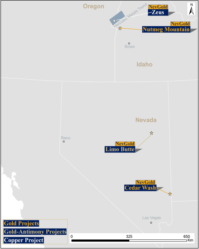
Figure 1 – Map of NevGold’s projects in the Western USA.

Figure 2 – Map of Washington County district in Southwest Idaho including the Nutmeg Gold Trend, and emerging Hercules Copper Trend. Nutmeg Mountain is approximately 30 km from the Hercules Copper Trend.
Property
The Nutmeg property consists of approximately 1,724 hectares and comprises 210 federal unpatented lode mining claims, 12 patented claims, and 2 leases of private land. The center of the Property is at approximately 116° 42.8’W latitude with Property extending along the crest and western slopes of Nutmeg Mountain.

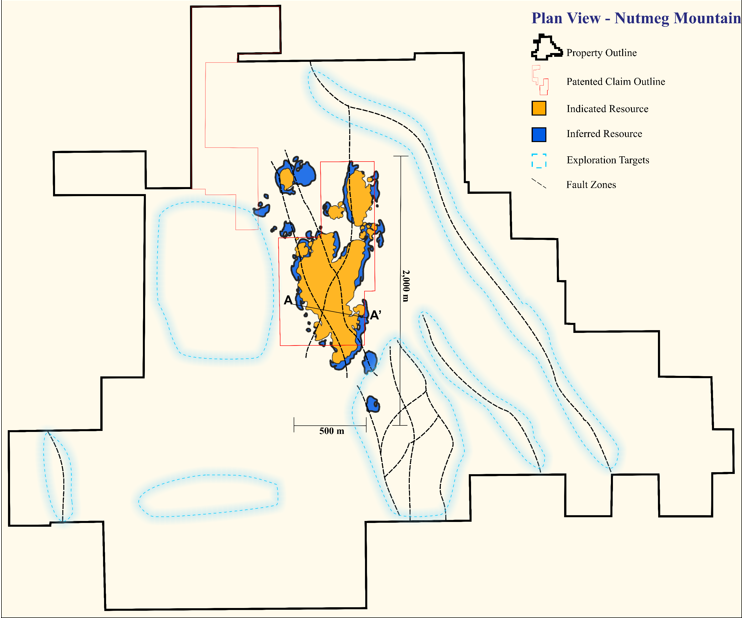
Figure 3 – Plan view map of Nutmeg Mountain gold project. Black line outlines the larger unpatented Bureau of Land Management (BLM) project boundary, with orange outline defining patented claims and private leases which do not have limitations on disturbance acreage allowed, and can be drilled with a notice to the State of Idaho. Blue dashed lines represent identified targets based on numerous geological data layers and work completed at the Project. To view image please click here
History
Nutmeg is located in a historic mining area and encompasses a near-surface, low-sulphidation epithermal gold deposit. The area has been explored for gold starting in 1980 with geological mapping, geochemical and geophysical surveying, several metallurgical bulk samples, and 934 historical drillholes with an aggregate length of over 70,000 meters.
Historical drilling at the Project focused on defining the disseminated gold mineralization that starts at surface. This drilling was nearly all vertical and averaged less than 75 meters depth. The potential for high-grade feeder systems at depth remains virtually untested. Until Nevgold’s 2023 drill program, the last drilling at the project had occurred in 2012.
Deposit Geology and Model
Nutmeg Mountain is a low-sulphidation epithermal gold deposit with exploration dating back to the 1980s. The Project is host to Miocene-age basalt and tuffaceous sediments, Payette Formation sandstone and siltstone, and lacustrine sedimentary rocks of the Pliocene-age Idaho Group.
Nutmeg has seen over 70,000 meters of historical drilling prior to 2012 with 934 core, RC, and rotary holes.
Most gold mineralization that has been identified at the Project to date occurs within a north-trending graben, which is where most of the drilling has been concentrated. The graben is bounded by faults on the east and west, and sedimentary units change in thickness and character across the bounding faults. Mineralization is associated with multi-phase hydrothermal brecciation and veining, strong silicification, acid alteration, and faulting. Much of the surface alteration is composed primarily of opaline silica and appears to be replacement of Payette Formation sandstone.
There are four principal zones of mineralization. The Main Zone is the most significant in size and contains most of the gold in the MRE. Gold mineralization is hosted primarily in silicified Payette Formation sandstone that has been subjected to multiple phases of hydrothermal alteration, brecciation, and veining. The Main Zone mineralization occurs over a north-south distance of approximately 1,200 meters, a width from 250 to 500 meters, and a vertical thickness of up to 180 meters. Most of the gold in the MRE is situated in the top 75 meters of this vertical thickness, creating an opportunity to expand the resource vertically with further deeper drilling and additional data.
The North Zone underlies the narrow ridge crest at the north end of the Project, approximately 600 meters northeast of the Main Zone. In the North Zone, gold mineralization occurs as an oval, north-trending, tabular body that is up to 60 meters thick, approximately 335 meters long (N-S) and 150 meters wide. The Stinking Water Zone lies approximately 400 meters west of the North Zone and 600 meters north of the Main Zone. The Cove Creek Zone is located 600 meters southeast of, and approximately 170 meters lower than the Main Zone, with little to no surface expression.

Figure 4 - Plan view map of Nutmeg Mountain gold project with geology summary. The red outlines define the mineralization at a 0.20 Au g/t cutoff. The gold dash outline represents areas with additional mineralization potential.
2025 Mineral Resource Estimate
An updated Nutmeg project updated Historical Mineral Resource Estimate information was disclosed in a News Release dated September 18, 2025.
Classification
Cutoff Grade
Au g /tTonnes
Gold Grade g/tonne
Gold
OzsIndicated
0.2
74,205,000
0.50
1,186,000
Inferred
0.2
49,749,000
0.34
548,00
See Notes below:
Compared to an earlier 2023 MRE, the base case pit-constrained indicated tonnage increased by over 18% and inferred by over 100%, with further upside identified with high priority drill targets.
Within the Resource, increasing the cut-off grade from the base case of 0.20 g/t Au to 0.60 g/t Au, the Project has 560,000 ounces of Indicated Resources at 0.92 g/t Au, and 85 kozs of Inferred Resources at 0.87 g/t Au. This higher grade mineralization starts at surface and is within the 0.20 g/t Au cut-off grade MRE. To date, the Company has not completed any mine scheduling studies on the MRE. Exploring for more potential high-grade mineralization will be a key focus as the project is advanced with further drilling and subsequent resource estimates. The strip ratio of the project based on conceptual pit-shells is expected to be less than 1:1, which is extremely low for an open-pit, oxide, heap-leach gold project.
Cut-Off
g/tClassification
Tonnes
Au
g/tAu
oz/tonGold Ounces
1.00
Indicated
5,433,000
1.31
0.038
230,000
1.00
Inferred
610,000
1.36
0.040
27,000
0.80
Indicated
10,061,000
1.12
0.033
362,000
0.80
Inferred
1,297,000
1.12
0.033
47,000
0.60
Indicated
19,025,000
0.92
0.027
560,000
0.60
Inferred
3,025,000
0.87
0.025
85,000
0.50
Indicated
26,353,000
0.81
0.024
688,000
0.50
Inferred
5,711,000
0.72
0.021
132,000
0.40
Indicated
37,167,000
0.71
0.021
844,000
0.40
Inferred
10,496,000
0.59
0.017
199,000
0.30
Indicated
52,556,000
0.60
0.018
1,014,000
0.30
Inferred
22,458,000
0.46
0.013
332,000
0.25
Indicated
62,626,000
0.55
0.016
1,105,000
0.25
Inferred
33,679,000
0.40
0.012
431,000
0.20
Indicated
74,205,000
0.50
0.015
1,186,000
0.20
Inferred
49,749,000
0.34
0.010
548,000
0.10
Indicated
95,465,000
0.42
0.012
1,294,000
0.10
Inferred
87,406,000
0.26
0.008
732,000
Notes:
- Effective date of this mineral resource estimate is August 29, 2025.
- All mineral resources have been estimated in accordance with Canadian Institute of Mining, Metallurgy and Petroleum definitions, as required under National Instrument 43-101 (“NI 43-101”). The Mineral Resource Statement was prepared by Greg Mosher, P. Geo (Global Mineral Resource Services, “GMRS”) in accordance with NI 43-101.
- Mineral Resources reported demonstrate a reasonable prospect of eventual economic extraction through additional exploration, as required under NI 43-101. Mineral Resources are not Mineral Reserves and do not have demonstrated economic viability. There is no certainty that all or any part of the estimated Mineral Resources will be converted into Mineral Reserves. The potential development of the Mineral Resources may be materially affected by environmental, permitting, legal, marketing, and other relevant issues.
- Mineral Resources are reported at a cut-off grade of 0.20 g/t Au for an open-pit mining scenario. Cut-off grades are based on a price of US$2350/oz gold, and a number of operating cost and recovery assumptions, including a reasonable contingency factor. Metallurgical recoveries of 80% were used. Densities based on lithology were assigned.
- Ounce (troy) = metric tonnes x grade / 31.10348. All numbers have been rounded to reflect the relative accuracy of the estimate.
- The quantity and grade of reported Inferred Mineral Resources are uncertain in nature and there has not been sufficient work to define these Inferred Mineral Resources as Indicated or Measured Mineral Resources. It is reasonably expected that many of the Inferred Mineral Resources could be upgraded to Indicated Mineral Resources with continued exploration, however, there is no assurance that further exploration will result in all or any part of the Inferred Mineral Resources being converted into Indicated Mineral Resources.
- Tonnages and ounces in the tables are rounded to the nearest thousand and hundred, respectively. Numbers may not total due to rounding.
Additional Exploration Potential
The work completed to date by the Company has identified several high priority drill targets for future drilling. Historical drilling was mainly focused on the outcropping and near-surface disseminated mineralization, which is primarily located on the patented mining claims and other privately owned ground. NevGold has identified numerous additional near-surface gold targets on the unpatented mining claims surrounding the private ground. Additionally, the average drill hole depth at the Project is less than 75 meters, and to date the potential high-grade feeder veins typically associated with low-sulphidation epithermal gold systems have yet to be identified. Discovering additional near-surface disseminated gold mineralization and the potential high-grade feeder structures will continue to be the focus of NevGold’s ongoing exploration.

Figure 5 - Cross-section looking north through the MRE block model with all blocks above a 0.10 g/t Au cut-off. Mineralization starts at surface, with a high-grade core outcropping. As shown, there is further mineralization beneath the US$2350/oz pit-shell used in

Figure 6 – Cross-section looking north through the MRE block model with 0.60 g/t Au cut-off. The higher grade mineralization is within the 0.20 g/t Au cut-off MRE and starts at surface. To date, the Company has not completed any mine scheduling studies on the MRE.
Development Plans
NevGold’s plans for advancing the Project in 2025 and beyond include:
- Continued drilling new targets with the objective of expanding the 2025 mineral resource laterally and at depth;
- Targeting the high-grade feeder system typically seen in low-sulphidation epithermal deposits; the high-grade feeder system has not been tested by prior operators with average historical drillhole depth to approximately 75 meters, and is an exceptional exploration target;
- Detailed metallurgical program to characterize variances in the deposit metallurgy and determine optimal recovery processes for a future Preliminary Economic Assessment (PEA);
- Gather other technical information in preparation for commencing a PEA;
- Permitting to allow for baseline environmental surveys to commence.

Register to receive news via email from NevGold Corp.
* Required FieldsForm not found